
Hurricane Ian intensifies into "extremely dangerous" Category 4 storm
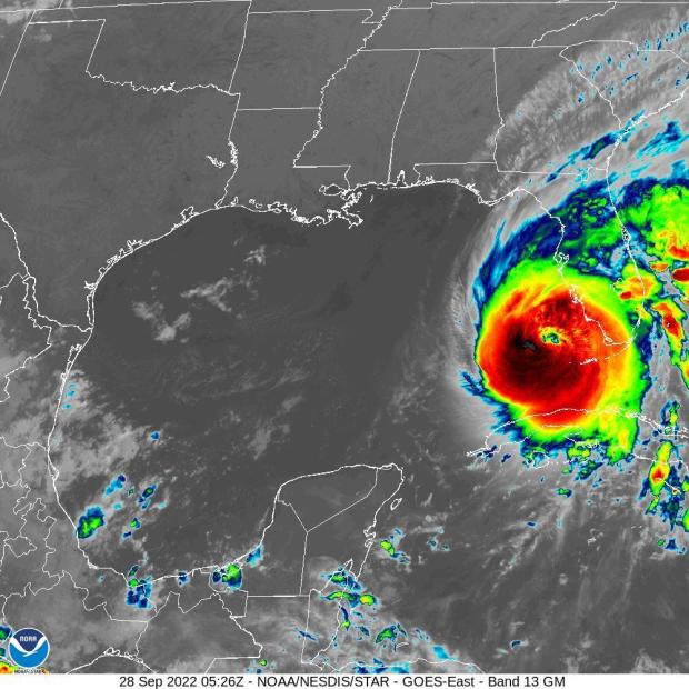
The National Hurricane Center said early Wednesday that Hurricane Ian had strengthened into an "extremely dangerous" Category 4 storm as it approached Florida's southwest coast. U.S. Air Force hurricane hunter planes had registered sustained winds of 140 mph.
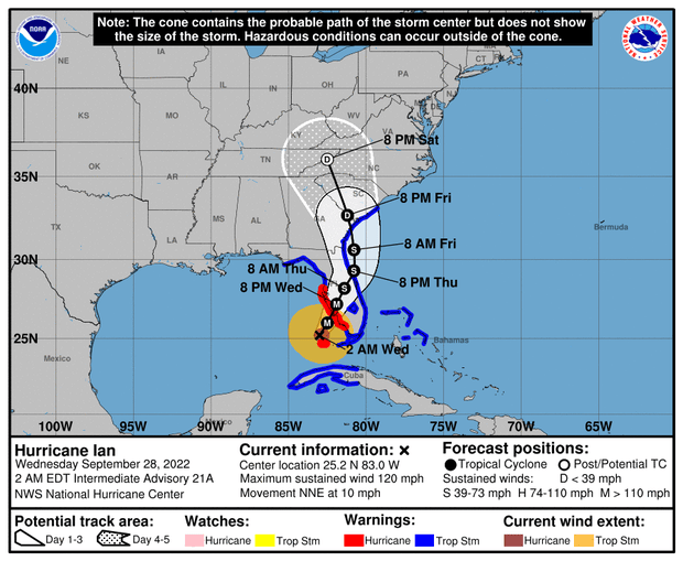
Ian was "expected to cause life-threatening storm surge, catastrophic winds and flooding in the florida peninsula," the center warned in a 5 a.m. Eastern advisory.
The storm was still tracking to the north-northeast at about 10 mph, and as of 5 a.m. its center was located only about 75 miles west-southwest of Naples, Florida.
Rainbands from Ian spreading over Florida mainland as storm nears southwest coast
At 4 a.m. Eastern, Hurricane Ian remained a Category 3 storm as it continued tracking to the northeast, heading for Florida's southwest coast at about 10 mph. The National Hurricane Center's latest update noted that bands of heavy rain spiraling out from the storm's center were hitting the Florida mainland. The center said a weather monitoring buoy just north-northwest of Ian's eye had measured a wind gust of 83 mph at sea.
As of 4 a.m. the storm was about 85 miles west-southwest of Naples, Florida, with landfall expected later in the day somewhere around Ft. Myers.
Tropical-storm-force winds start lashing mainland Florida's coasts
Hurricane Ian started lashing Florida's southern coasts — on both sides of the peninsula — with tropical-storm-force winds early Wednesday morning. The National Hurricane Center said in a 3 a.m. Eastern update that a weather station near Biscayne Bay, on the southeast coast, had registered gusts over 60 mph, while another station near Sanibel Island in the west clocked wind speeds near 50 mph.
The Category 3 hurricane was still packing sustained winds of 120 mph as it churned north-northeast toward Florida's southern west coast, with the eye located about 90 miles southwest of the city of Naples at 3 a.m.
2 a.m. Eastern update from National Hurricane Center
The latest update from the National Hurricane Center put Ian approximately 95 miles southwest of Naples, Florida. The weather service continued to warn that the Category 3 storm was "expected to cause life-threatening storm surge, catastrophic winds and flooding" in much of the Florida peninsula, with the state's western coast bearing the brunt.
The hurricane remained on a path headed north-northeast toward the Tampa Bay region at roughly 10 mph, with sustained winds of about 120 mph.
"Rapid intensification" seen with Ian is a rising trend
As Hurricane Ian roared towards Florida, it experienced a phenomenon known as rapid intensification — getting very strong, very fast. Scientists say the process of hurricanes rapidly intensifying is becoming more frequent, and is connected to the impact of human-caused climate change.
Rapid intensification is defined by meteorologists as increase in the maximum sustained winds of a tropical cyclone of at least 30 knots (about 35 mph) in a 24 hour period, according to the U.S. National Hurricane Center.
Click here to learn more about rapid intensification, how it's been a factor with Hurricane Ian, and the role climate change plays in the increase of the phenomenon.
Ian causing storm surge and high wind in Florida Keys
The National Hurricane Center said in a 1 a.m. Eastern advisory on Wednesday that Hurricane Ian was causing storm surge flooding across the lower Florida Keys. Winds in the area were picking up, too, topping 60 mph as the storm continued along its northward path toward Florida's west coast, with the island chain to it's east, moving at about 10 mph.
Ian was about 105 miles southwest of Naples, Florida, with sustained winds of 120 mph.
The National Ocean Service said the water level on Key West was already about 2.5 feet above normal levels.
Storm surge warning issued for Florida Keys
The National Hurricane Center issued a storm surge warning for the lower Florida Keys, from Big Pine Key to Key West, early Wednesday morning. Water levels had already risen 2 feet above normal high tide in Key West late Tuesday night.
At 12:30 a.m. ET Wednesday, Hurricane Ian was located about 100 miles southwest of Naples, Florida. It was moving north-northeast at 10 mph and had maximum sustained winds of 120 mph.
Water levels in Key West rising
Water levels in Key West, Florida, have already risen more than 2 feet above normal high tide, according to the National Oceanic and Atmospheric Administration.
Hurricane position and strength as of 11 p.m. ET
At 11 p.m. ET, Hurricane Ian was located about 110 miles southwest of Naples, Florida, according to the National Hurricane Center. It was moving north-northeast at 10 mph and had maximum sustained winds of 120 mph, making it a Category 3 storm.
Storm location and strength as of 10 p.m. ET
As of 10 p.m. ET, Hurricane Ian was located about 175 miles south-southwest of Punta Gorda, Florida, and about 5 miles south of The Dry Tortugas. It was moving north-northeast at 10 mph and had maximum sustained winds of 120 mph.
Hurricane Ian lashes Cuba as it heads for Florida coast
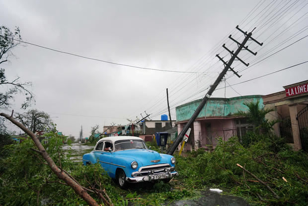
Hurricane Ian tore into western Cuba as a major hurricane Tuesday and left 1 million people without electricity, then churned on a collision course with Florida over warm Gulf waters amid expectations it would strengthen into a catastrophic Category 4 storm.
Ian made landfall in Cuba's Pinar del Rio province, where officials set up 55 shelters, evacuated 50,000 people, and took steps to protect crops in the nation's main tobacco-growing region. The U.S. National Hurricane Center said Cuba suffered "significant wind and storm surge impacts" when the hurricane struck with top sustained winds of 125 mph (205 kmh).
Read more here.
Tampa fire chief discusses Hurricane Ian preparations
Location and speed of Ian as of 8 p.m. ET
At 8 p.m. ET, Hurricane Ian was located about 180 miles south-southwest of Punta Gorda, Florida, and 20 miles south-southwest of the Dry Tortugas, according to the National Hurricane Center. The storm was moving north-northeast at 10 mph and had maximum sustained winds of 120 mph.
"You can hide from the wind, but you need to run from that water": Tampa mayor on Hurricane Ian threat
Tampa Mayor Jane Castor urged those who have not evacuated the area as Hurricane Ian approaches to do so, predicting that the city will lose power and could see a tidal surge.
"We used to have the old 'Well, we can just wait this out and see what happens,'" Castor told "CBS Evening News" anchor and managing editor Norah O'Donnell on Tuesday. "We're talking 10- to 15-foot tidal surge. Nobody can withstand that. There's no waiting that out."
"We always use the adage, you can hide from the wind, but you need to run from that water," Castor said.
Read more here.
Disney World closing theme and water parks
Disney World announced that it is closing all theme and water parks on Wednesday and Thursday as it braces for Hurricane Ian. ESPN's Wide World of Sports Complex will also be closed and any Star Wars: Galactic Starcruiser "voyages" that were scheduled to begin Tuesday or Thursday have been canceled, the park announced.
Disney hotels and resorts will remain open, however, guests must check in by 3 p.m. Wednesday and will be required to shelter in place "for the duration of the storm." Cancellation fees will be waived for guests who wish to rebook their stays or cancel outright, the park said.
Disney World also warned that dining options for hotel guests "will vary, and in some cases may be very limited."
Read more here.
Biden speaks with DeSantis
President Biden spoke with Florida Governor Ron DeSantis "to discuss the steps the federal government is taking to help Florida prepare for Hurricane Ian," White House press secretary Karine Jean-Pierre said. Details of the conversation were not released, but both "commited to continued close coordination," Jean-Pierre said.
President Biden spoke this evening with Governor DeSantis of Florida to discuss the steps the Federal government is taking to help Florida prepare for Hurricane Ian. The President and the Governor committed to continued close coordination.
— Karine Jean-Pierre (@PressSec) September 27, 2022
Tracking Hurricane Ian's expected landfall
Evacuations underway as Hurricane Ian barrels toward Florida
Piney Point under 24-hour supervision ahead of Hurricane Ian
Piney Point, a former phosphate mining facility in Manatee County, Florida, is undergoing 24-hour surveillance ahead of Hurricane Ian, CBS News has learned. The site made headlines last year when a massive leak was detected in the liner of a gypsum stack. The issue resulted in millions of gallons of wastewater ending up in Tampa Bay and helped contribute to a devastating months-long red tide event.
Florida Agricultural Commissioner Nikki Fried told CBS News on Tuesday that she had spoken with Florida's Department of Environmental Protection earlier in the day and that they do not foresee Hurricane Ian being "a huge problem," given its current forecasts.
"Based on the water that is currently in Piney Point, they can sustain about 25 inches of rain. And thinking that we're supposed to get 12 to 15 inches of rain, they are not seeing this to be a huge problem," Fried said.
Fried said the department informed her that the water has been partially treated, so that even if there is an overflow, "it won't be of issue."
However, the treatment of that water, she told CBS News, is something she "never had full trust and confidence in."
The site is undergoing 24-hour monitoring, Fried said.
The state's dedicated site for Piney Point updates last provided information on Friday, saying that preparations also include staging backup pumps and adjusting water management levels. There are roughly 268 million gallons in the site's reservoir.
According to Manatee County's evacuation maps, Piney Point is in evacuation zone B, meaning that the area could see a potential surge inundation of 14 feet.
The county issued mandatory evacuations for those in zones A and B on Tuesday. Those in zone C have been recommended to evacuate.
The state is more concerned with construction equipment on site, which the department is in the process of "hunkering down" and moving offsite to avoid heavy winds turning the equioment into projectiles. A deep injection well, approved in December, is under construction to hold the water that is in the reservoir, and the site is currently in the initial process of closing its south compartment, according to the website. Part of the process involves grading and shaping the area so it doesn't accumulate rainwater.
"The secretary seems to be pretty confident that they should be OK with the amount of rain," Fried said. "Of course, if it was to be head-on with 140 mph sustained wind, that would be an issue. But with this just potentially being a rain event more than anything else in that Piney point area, he felt confident that they could sustain the rain."
Hurricane warning extended south
The National Hurricane Center extended a hurricane warning southward along Florida's west coast. The warning now stretches from the Anclote River down to Chokoloskee.
In addition, the storm surge watch from Marineland to the Flagler/Volusia County Line has been upgraded to a storm surge warning, the NHC said.
Hurricane location as of 5 p.m. ET
As of 5 p.m. ET, Hurricane Ian was located roughly 230 miles south of Sarasota, Florida, and about 50 miles south-southwest of the Dry Tortugas, the National Hurricane Center said. The storm had maximum sustained winds of 120 mph and was moving north at 10 mph.
House Jan. 6 panel postpones hearing due to Ian
The House committee investigating the Jan. 6 attack on the U.S. Capitol has postponed a hearing scheduled for Wednesday due to Hurricane Ian.
"In light of Hurricane Ian bearing down on parts of Florida, we have decided to postpone tomorrow's proceedings. We're praying for the safety of all those in the storm's path," the committee said in a statement. "The Select Committee's investigation goes forward and we will soon announce a date for the postponed proceedings."
Read more here
College football games moved because of Ian
Florida's home football game against Eastern Washington has been moved from Saturday to Sunday because of Hurricane Ian.
The Gators and Eagles will kick off at noon in Gainesville shortly before NFL games around the country.
Also, South Florida and East Carolina, which had been slated to play in Tampa on Saturday night, will instead play in Boca Raton. The game will now kick off at 2:30 p.m. at Florida Atlantic's stadium.
The University of Florida canceled classes and all student-related activities Wednesday through Friday in anticipation of Ian's predicted landfall.
Meanwhile, South Carolina's home game with South Carolina State has been moved from Saturday to Thursday night due to Ian's track.
Warning and watches as of 2 p.m. ET
What the hurricane categories mean
Hurricanes are rated on the Saffir-Simpson Hurricane Wind Scale, which includes five categories based on the storm's sustained wind speeds. It also estimates possible damage to property, ranging from "some damage" to "catastrophic."
If a storm is a Category 3, 4 or 5, it is deemed a "major" hurricane due to the potential for "significant loss of life and damage," the National Hurricane Center says. Hurricanes that fall into categories 1 or 2 are still considered dangerous, the center says.
Read more here
Uber offering discounted rides to hurricane shelters
Residents of Florida's Gulf Coast who need to evacuate to a shelter ahead of Hurricane Ian are eligible for a discounted Uber ride to do so, Governor Ron DeSantis' office announced. The discounted rides are eligible for residents in Hillsborough, Pinellas, Manatee and Pasco counties.
DeSantis' office said that Uber will be offering the round-trip rides to and from state-approved shelters. The promotional code "IANRELIEF" will take up to $30 off the ride each way. FloridaDisaster.org maintains a list of shelters available.
Read more here
Hurricane Ian disrupts energy sector
Hurricane Ian is disrupting the energy sector, with oil producers BP and Chevron halting production at offshore oil platforms in the Gulf of Mexico.
On Monday, BP said it had evacuated personnel from its Na Kika platform, which produces 130,000 barrels of oil per day as well as 550 million cubic feet per day of natural gas. It is also cutting production at its Thunder Horse platform, which produces 250,000 barrels of oil per day, as well as 200 million cubic feet per day of natural gas.
Chevron also said it is removing personnel from its Petronius and Blind Faith platforms and temporarily suspending operations at the facilities. Combined, they produce around 120,000 barrels of oil per day.
Read more here
Orlando airport announces operations will halt
Orlando International Airport said commercial operations will halt Wednesday at 10:30 a.m. due to Hurricane Ian.
"Entry to all parking facilities will be closed at that same period," said the airport, which is located northeast of Tampa, in central Florida.
Passengers are advised to contact their airlines regarding flight updates.
Operational Update – Hurricane Ian
— Orlando International Airport (@MCO) September 27, 2022
Commercial operations at MCO will cease at 10:30 a.m. Wednesday, 09/28/22. Entry to all parking facilities will be closed at that same period. Please contact your airline for flight updates. pic.twitter.com/P75DooP2EA
County official calls evacuation centers a "last resort"
The emergency management chief for Sarasota County, on Florida's west coast, gave some advice for people considering riding out Hurricane Ian in an evacuation center.
"Evacuation centers … should be your last resort," Ed McCrane said during a press conference with Gov. Ron DeSantis. "They're the lifeboat. You should go to friends or family if you can, and you don't have to go hundreds of miles. You can go tens of miles. You can choose east-west routes."
People seeking shelter could also head south, McCrane said.
"If you're going to an evacuation center, eat before you go, bring your emergency kit, including bedding, and bring a flashlight, toiletries," McCrane said. "You're going to get 20 square feet of space there."
He said all of the county's evacuation centers are pet-friendly.
Disney World announces closures
Evacuations ordered for 8 Florida counties
"People … who decide not to go, they do so at their own peril"
Lee County — where Fort Myers is on Florida's southwest Gulf Coast — issued mandatory evacuations early Tuesday for low-lying areas including Fort Myers Beach, Sanibel and Bonita Beach, where about 250,000 people live, after forecasters expanded the hurricane warning area.
"People on the barrier islands who decide not to go, they do so at their own peril," Lee County Manager Roger Desjarlais said early Tuesday. "The best thing they can do is leave."
"It's a dangerous place to be," Desjarlais said. "We cannot by law force people off the islands, but we strongly recommend that they go."
🚨 Tues 9/27/22, 10AM: Mandatory evacuations are in effect for vulnerable areas of Charlotte, Hillsborough, Lee, Levy, Manatee, Pasco, Pinellas & Sarasota counties.
— FL Division of Emergency Management (@FLSERT) September 27, 2022
Pinellas County residents urged to finalize shelter plans
Residents of Pinellas County, which is located just west of Tampa, are being urged by local officials to finalize their shelter plans as Hurricane Ian nears.
Mandatory evacuations were ordered for the county's Zone A and mobile homes on Monday, and for Zones B and C Tuesday morning.
"Residents should finalize their sheltering plans soon, whether it is in their non-evacuation zone home, in a hotel, or with a friend or family member," the county tweeted Tuesday. "There are 25 shelters currently open around the county."
Residents should finalize their sheltering plans soon, whether it is in their non-evacuation zone home, in a hotel, or with a friend or family member. There are 25 shelters currently open around the county. Click the link to find the shelter closest to you. 1/2 pic.twitter.com/lWtvq6cgdO
— Pinellas County (@PinellasCoNews) September 27, 2022
Warnings and watches in effect as of 11 a.m. ET
Sarasota, Florida, announces closures
Sarasota, Florida, which is located just north of where Hurricane Ian is expected to make landfall, says the city's administrative offices will close Tuesday at noon and not open until Friday, "conditions permitting."
The Siesta and John Ringling Causeway bridges will be closed to non-residents at 3 p.m., and then will close to all vehicles at 6 p.m.
At 7 p.m., water will be shut off to the barrier islands.
City of Sarasota admin offices will close @ NOON today.
🌉Bridge closures will start @ 3 pm.
🚰Barrier island water shutoff @ 7 pm.
🚛No garbage collection ThursdayDETAILS: https://t.co/HG1gJSJk8L pic.twitter.com/LxGJmNe3u6
— City of Sarasota (@CityofSarasota) September 27, 2022
Tampa airport suspending operations
Hurricane Ian is impacting air travel, with Tampa International Airport announcing it will halt operations Tuesday starting at 5 p.m.
"The 5 p.m. closure will allow the Airport to prepare the airfield and terminals, including the securing of jet bridges, ground equipment, and any remaining aircraft," the airport says. "The Airport, including the Main Terminal, Airsides, and parking garages will be closed to all visitors at that time."
ICYMI: TPA leaders provided an update regarding Hurricane Ian’s impacts on Airport operations and planned recovery. The Airport will be suspending operations at 5 p.m. today.
Watch it here: https://t.co/WtZ5YbWka5
— Tampa International Airport ✈️ (@FlyTPA) September 27, 2022
Disney World is open for now
Walt Disney World, which is located in central Florida, says on its website it is "operating under normal conditions" as it prepares to make "necessary adjustments" based on the latest weather information.
It asked people to continue checking its site for the most up-to-date information about temporary impacts and park closures as Hurricane Ian nears.
"We continue to put the safety of our Cast Members and Guests first and will share updates with you as we monitor Hurricane Ian," it says.
Disney World is located about 125 miles northeast of where Ian is expected to make landfall.
Manatee County issues mandatory evacuation order
A mandatory evacuation order is in place for Manatee County's zones A and B. Zone C is under a voluntary evacuation order, officials tweeted Tuesday.
Zones can be found using this interactive map.
If you do not know your evacuation zone, please use this interactive Evacuation Zone Map - https://t.co/CyR804YpXU
For info on shelters, sandbag distribution, evacuation zones, special needs registry, and more, visit: https://t.co/7Dks4mQyZB#HurricaneIan #ManateeReady
— Manatee Sheriff (@ManateeSheriff) September 27, 2022
"Your window to prepare … essentially is going to be closing later today"
Michael Brennan, acting deputy director of the National Oceanic and Atmospheric Administration, told CBS News people in Florida should follow evacuation orders from their local officials as Hurricane Ian heads toward the state's west coast.
"If you live in one of these storm surge evacuation zones and you've been asked to leave, please do so because your window to prepare and get ready for the storm essentially is going to be closing later today, and by tonight, you're going to need to be where you're going to ride out the storm," Brennan said.
Brennan said Tuesday morning the storm surge threat applies to the state's west coast from north of Tampa to Collier County in the southern part of the state, a large area that includes Fort Myers, Naples, Port Charlotte and Sarasota.
Ian's winds could damage homes and cause widespread power outages, Brennan said.
Landfall predicted in Venice Wednesday
Hurricane Ian is forecast to make landfall Wednesday evening in Venice, Florida, south of Tampa, Kevin Guthrie, director for the Florida Division of Emergency Management, said at a press conference Tuesday morning. It is expected to hit as a Category 3 storm.
"The National Hurricane Center is now predicting that landfall will be Venice in 35 hours, at 125 mph ... making it a major, Category 3, landfalling hurricane," Guthrie said at the press conference, which was held at 9 a.m. Tuesday.
Guthrie said the best option for many people in the southwest Florida area is to evacuate across the state.
"Just go straight across the state to Broward, Miami-Dade, Palm Beach. Don't try to go north," he said, nothing that this will help ease traffic.
Residents can find out if they live in an evacuation zone by visiting FloridaDisaster.org/know or FloridaDisaster.org/planprepare, he said.
Florida governor warns of "catastrophic" and "life-threatening" impacts
Florida Governor Ron DeSantis warned that catastrophic flooding and life-threatening storm surge will be seen in some areas as Hurricane Ian hits the state's west coast on Wednesday.
He urged people to heed evacuation orders, which identify people living in areas that are vulnerable to major storm surge. People evacuating don't need to go to another state, he noted, saying shelters are open in other parts of Florida.
"Impacts will be far, far broader than where of the eye makes landfall," he said at a press conference Tuesday morning.
Evacuation orders in effect in Hillsborough County
Mandatory and voluntary orders have been issued for Hillsborough County, Florida, which is home to Tampa.
Zone A in the county is under a mandatory evacuation notice and Zone B is under a voluntary evacuation notice.
"Those living in mobile and manufactured homes are encouraged to evacuate as well," the county tweeted Monday.
Evacuation zones can be seen in this interactive evacuation assessment tool.
Ian moves over western Cuba
The center of Hurricane Ian is moving north over western Cuba Tuesday morning, with tropical storm force winds extending outward 115 miles. The storm made landfall at 4:30 a.m. ET in Cuba's Pinar del Rio province, where officials set up 55 shelters, evacuated 50,000 people, rushed in emergency personnel and took steps to protect crops in Cuba's main tobacco-growing region.
Cuba's capital was getting rain and strong gusts, and Havana's residents openly worried about flooding ahead of the storm, with workers unclogging storm drains and fishermen taking their boats out of the water.
"I am very scared because my house gets completely flooded, with water up to here," Adyz Ladron said, pointing to his chest.
In Havana's El Fanguito, a poor neighborhood near the Almendares River, residents packed up what they could.
"I hope we escape this one because it would be the end of us. We already have so little," health worker Abel Rodrigues said.
Ian's forward movement was expected to slow over the gulf, enabling the hurricane to grow wider and stronger before it brings punishing wind and water to Florida's west coast.
