
A snowfall warning is in effect for Metro Vancouver, with up to 20 cm expected in some cities.
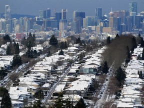
VANCOUVER, B.C.: Tuesday, Nov. 29. Bundle up, Metro Vancouver. It’ll be a cloudy and frigid Tuesday morning, with a temperature of -9 C including wind chill this morning. A large snow dump is expected later this afternoon into the evening. Environment Canada has issued a snowfall warning for Metro Vancouver and the Fraser Valley. The snow storm is expected to start late afternoon and last until early Wednesday, when it’ll taper off to showers or rain. North Vancouver, Coquitlam and Maple Ridge could see up to 20 cm, while Vancouver, Burnaby, Surrey, Langley, New West and Abbotsford could see 10 to 15 cm.
Start your day with a roundup of B.C.-focused news and opinion delivered straight to your inbox at 7 a.m., Monday to Friday.
Thanks for signing up!
A welcome email is on its way. If you don't see it, please check your junk folder.
The next issue of Sunrise presented by Vancouver Sun will soon be in your inbox.
Weather: Vancouver, B.C.
Today: Cloudy. 40 percent chance of flurries this afternoon. Snow beginning late this afternoon. Wind becoming east 20 km/h gusting to 40 this morning. High zero. Wind chill minus 9 this morning.
Tonight: Snow mixed with rain changing to rain before morning. Snowfall amount 10 to 15 cm. Wind east 20 km/h gusting to 40 becoming light near midnight. Wind becoming southwest 20 gusting to 40 before morning. Temperature rising to plus 4 by morning.
Tomorrow: A mix of sun and cloud. 60 percent chance of showers in the morning. Wind southwest 20 km/h gusting to 40 becoming light in the afternoon. High plus 5. UV index 1 or low.
Source: Environment and Climate Change Canada
Air Quality: Vancouver

Traffic: Vancouver
Zoom in and out to find incidents of note or to peek at a traffic camera.
