
CNN —
Hurricane-strength Fiona is ripping through Canada’s eastern seaboard after making landfall in Nova Scotia early Saturday, slamming the area with fierce rain and winds and knocking out power for hundreds of thousands in what could be a “landmark” weather event for the country.
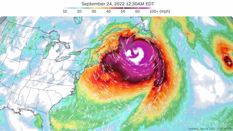
Fiona, now a post-tropical cyclone, had maximum sustained winds of 80 mph – the power of a Category 1 hurricane – around 11 a.m. ET Saturday, with its center over the Gulf of St. Lawrence and heading toward eastern Quebec and Newfoundland and Labrador, the US National Hurricane Center said.
The storm has wiped out power to most of Nova Scotia and Prince Edward Island Saturday morning, with winds and rains extending far from the storm’s center. More than 540,000 outages were reported in Atlantic Canada, including to nearly all of Prince Edward Island’s 86,000 customers, according to utility tracker Poweroutage.com.
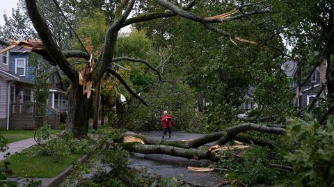
The storm made landfall in the darkness of early Saturday as a powerful post-tropical cyclone in eastern Nova Scotia, between Canso and Guysborough, and crossed over the province’s Cape Breton Island. Officials in Cape Breton area declared an emergency and asked people to shelter in place.
“Across the province, we’re hearing reports of damaged trees and power lines as the storm continues to pass through,” the Nova Scotia Emergency Management Office tweeted.
West of landfall, in Nova Scotia’s capital, Halifax, an apartment complex’s roof collapsed, forcing about 100 people to leave for a shelter, Mayor Mike Savage told CNN Saturday.
“A lot of uprooted trees – power outages all over the place. Our bridges, our connections to transit, are all closed out,” Savage said.
In the Prince Edward Island capital of Charlottetown, police tweeted photos of damage including a home’s collapsed ceiling.
“Conditions are like nothing we’ve ever seen,” Charlottetown police tweeted early Saturday.
Several buildings were blown apart In the coastal community of Burnt Islands in Newfoundland and Labrador, video posted to Facebook by Pius Scott showed. Homes – or parts of them – collapsed in heaps, and debris littered the ground and seawater.
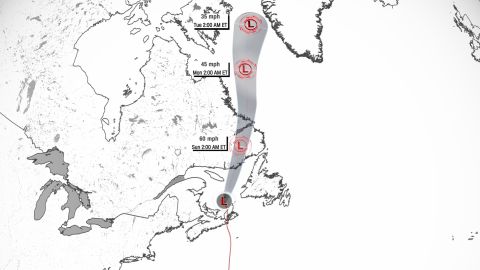
After passing through the Gulf of St. Lawrence, Fiona should reach Quebec’s lower north shore and Newfoundland and Labrador by late Saturday, the Canadian Hurricane Centre said.
Hurricane-force gusts were reported Saturday across parts of Maritime Canada, generally ranging from 70 to 95 mph (110 to over 150 kph). A top gust as of mid-morning was 111 mph (179 kph) in Arisaig, Nova Scotia, according to Environment Canada.
Rainfall could total up to 10 inches in some places, and significant flooding is possible, forecasters said.
Officials along Canada’s Atlantic seaboard had urged people to be on high alert for the storm, which has already claimed the lives of at least five people and shut off power for millions as it battered multiple Caribbean and Atlantic islands this week.

Fiona “could be a landmark event for Canada in terms of intensity of a tropical cyclone,” and it could even become Canada’s version of Superstorm Sandy, said Chris Fogarty, Canadian Hurricane Centre manager. Sandy in 2012 affected 24 states and all of the eastern seaboard, causing an estimated $78.7 billion in damage.
An unofficial barometric pressure of 931.6 mb was recorded at Hart Island, which would make Fiona the lowest pressure land-falling storm on record in Canada, according to the Canadian Hurricane Centre.
Fiona had been a Category 4 storm early Wednesday over the Atlantic after passing the Turks and Caicos and remained so until Friday afternoon, when it weakened on approach to Canada.
It became post-tropical before making landfall – meaning instead of a warm core, the storm now had a cold core. This does not affect the storm’s ability to produce intense winds, rain and storm surge – it just means the storm’s interior mechanics have changed.
Fiona approached Canada at the same time as a trough of low pressure and cold air to the north – much like Sandy did, according to Bob Robichaud of the Canadian Hurricane Centre.
“Sandy was larger than Fiona is expected to be even. But the process is essentially the same – where you have two features kind of feeding off each other to create one strong storm like we’re going to see,” he said Friday.
As of 8 a.m. Saturday, hurricane-force winds extended up to 175 miles out from Fiona’s center while tropical-storm-force winds reached up to 405 miles out, according to the US National Hurricane Center.
Large swells generated by Fiona could cause life-threatening surf and rip currents along not only Atlantic Canada, but also the US Northeast coast and Bermuda, the hurricane center said.
