
Southwest Florida bracing for Hurricane Ian's arrival
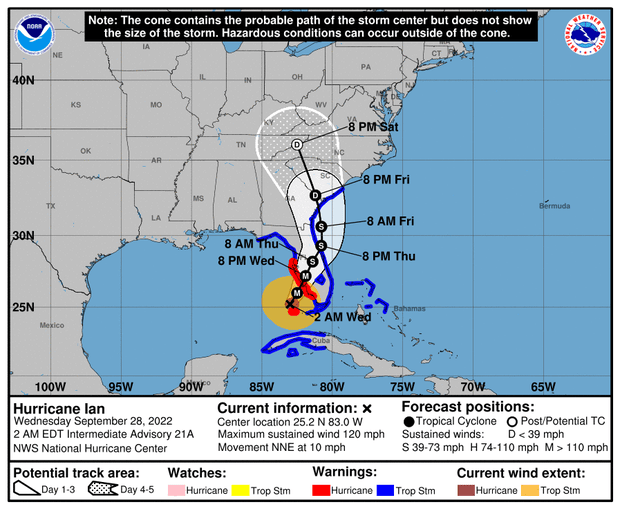
Hurricane Ian grew into an "extremely dangerous" Category 4 storm packing sustained winds of 140 mph early Wednesday, just hours before was expected to make landfall on Florida's southwest coast. About 2.5 million people were under mandatory evacuation orders as the hurricane started lashing the Florida peninsula with heavy rain and tropical-storm-force winds in the early hours.
Ian tore across western Cuba on Tuesday packing sustained winds up to 125 mph. Damage from the storm knocked Cuba's power grid offline, leaving the entire country in the dark Wednesday morning.
Tampa Bay and St. Petersburg were among the cities bracing for the worst of the storm, but the latest forecasts suggested Ian would make landfall slightly further south, with the Ft. Myers region at risk of a possible direct hit. Given the size and strength of the hurricane and the storm surge it's expected to drive into coastal areas, officials were clear that much of Florida remained at risk.
"It's important to say that Tampa Bay region, you are not out of the woods yet," Florida Director of Emergency Management Kevin Guthrie said Tuesday, urging residents to "heed the warnings that are in place."
Hurricane Ian intensifies into "extremely dangerous" Category 4 storm
The National Hurricane Center said early Wednesday that Hurricane Ian had strengthened into an "extremely dangerous" Category 4 storm as it approached Florida's southwest coast. U.S. Air Force hurricane hunter planes had registered sustained winds of 140 mph.
Ian was "expected to cause life-threatening storm surge, catastrophic winds and flooding in the florida peninsula," the center warned in a 5 a.m. Eastern advisory.
The storm was still tracking to the north-northeast at about 10 mph, and as of 5 a.m. its center was located only about 75 miles west-southwest of Naples, Florida.
Tropical-storm-force winds start lashing mainland Florida's coasts
Hurricane Ian started lashing Florida's southern coasts — on both sides of the peninsula — with tropical-storm-force winds early Wednesday morning. The National Hurricane Center said in a 3 a.m. Eastern update that a weather station near Biscayne Bay, on the southeast coast, had registered gusts over 60 mph, while another station near Sanibel Island in the west clocked wind speeds near 50 mph.
The Category 3 hurricane was still packing sustained winds of 120 mph as it churned north-northeast toward Florida's southern west coast, with the eye located about 90 miles southwest of the city of Naples at 3 a.m.
"Rapid intensification" seen with Ian is a rising trend
As Hurricane Ian roared towards Florida, it experienced a phenomenon known as rapid intensification — getting very strong, very fast. Scientists say the process of hurricanes rapidly intensifying is becoming more frequent, and is connected to the impact of human-caused climate change.
Rapid intensification is defined by meteorologists as increase in the maximum sustained winds of a tropical cyclone of at least 30 knots (about 35 mph) in a 24 hour period, according to the U.S. National Hurricane Center.
Click here to learn more about rapid intensification, how it's been a factor with Hurricane Ian, and the role climate change plays in the increase of the phenomenon.
- In:
- Weather Forecast
- Hurricane Ian
- Severe Weather
- Florida
- Hurricane
Tucker Reals is the CBSNews.com foreign editor, based at the CBS News London bureau.
