
Wastewater treatment plant in Bradenton nearly overflowing, city says
A wastewater treatment plant in Bradenton is full and "in danger of overflowing,"according to the city's Facebook page.
The city asked all of its residents to "PLEASE CONSERVE WATER" by refraining from washing dishes or laundry, flushing the toilet only when necessary, and limiting showering.
Hurricane Ian knocks out power to half a million Floridians within its first hours
Prior to Ian making landfall on Wednesday, the storm was already unleashing its wrath on Florida's power grids.
Before 2:30 p.m. ET, more than 640,000 Floridians had their power knocked out, according to tracking on poweroutage.us. Southwest Florida has so far bore the brunt of the impact, with Lee County — home to Fort Myers — reporting more than 226,000 outages, affecting nearly 50% of its tracked customers.
Neighboring Collier County had more than 99,000 outages reported at the same time.
Read more here
Water receded out of Tampa Bay during Hurricane Ian
As Hurricane Ian made its way toward Florida on Wednesday, it appeared water had receded from Tampa Bay, as if the body of water had been drained and dried out. The phenomenon, called a blowout tide or a reverse storm surge, is an indicator that a hurricane is on its way.
A blowout tide often occurs during low tide, when strong winds blowing directly off shore push the water out, exposing the bottom of the body of water, according to The Weather Channel.
Walking on the newly exposed shore during blowout tide could be dangerous because the winds could rapidly change, and the tide could come back.
Charlotte Harbor is going in reverse… pic.twitter.com/3XX34rptwS
— Brett Adair (@AlaStormTracker) September 28, 2022
Read more here
Warning and watches in effect as of 2 p.m.
The National Hurricane Center said the following warnings and watches were in effect as of 2 p.m ET:
A hurricane warning is in effect for:
-Chokoloskee to Anclote River, including Tampa Bay
-Sebastian Inlet to Flagler/Volusia County Line
A storm surge warning is in effect for:
-Suwannee River southward to Flamingo
-Tampa Bay
-Lower Florida Keys from Big Pine Key westward to Key West
-Flagler/Volusia Line to the mouth of the South Santee River
-St. Johns River
A tropical storm warning is in effect for:
-Indian Pass to the Anclote River
-All of the Florida Keys
-Flamingo to Sebastian Inlet
-Flagler/Volusia County Line to Little River Inlet
-Flamingo to Chokoloskee
-Lake Okeechobee
-Florida Bay
-Bimini and Grand Bahama Islands
A storm surge watch is in effect for:
-Florida Keys from the Card Sound Bridge westward to east of Big
Pine Key
-Florida Bay
A hurricane watch is in effect for:
-Flagler/Volusia County Line to the South Santee River
-Lake Okeechobee
DeSantis to submit disaster declaration covering all Florida counties
Hurricane Ian continued to approach the southwestern coast of Florida on Wednesday afternoon with 155 mph winds. As Gov. Ron DeSantis noted at a news conference in Tallahassee, that number is "just shy" of the 157 mph threshold that constitutes a Category 5 hurricane, which, he reiterated, "is incredibly dangerous."
"If you are still in southwest Florida, just stay inside," the governor added. He said the sheriff in Charlotte County, one of the areas where Ian is expected to make landfall, told him earlier that some people had evacuated, while others had not.
In preparation for debris cleanup and other relief operations that will likely be necessary across the state after the hurricane passes, DeSantis said that he is going to submit a major disaster declaration for all Florida counties. The declaration will request that the federal government reimburse 100% of upfront costs to the state for 60 days, to "ensure that we can quickly recover and move forward."
Simone Marstiller, secretary of Florida's agency for health care administration, said more than 7,000 patients and residents have so far been evacuated from 150 care facilities statewide. The agency has also activated Floria's emergency patient lookup system, a database that will allow special needs shelters in impacted areas to share records and other identifying information that could help locate "missing or displaced" patients after the storm.
23 missing after migrant boat sinks during Hurricane Ian, U.S. official says
A boat carrying migrants sank and left 23 people missing as Hurricane Ian lashed the Florida coast on Wednesday, U.S. Border Patrol said Wednesday. Four people on the boat were able to swim to shore, officials said.
"U.S. Border Patrol agents... responded to a migrant landing in Stock Island, Florida," Miami Chief Patrol Agent Walter Slosar said on Twitter. "Four Cuban migrants swam to shore after their vessel sank due to inclement weather."
The U.S. Coast Guard retweeted Slosar's tweet, adding that it too is searching for the missing.
Read more here
Traffic cameras show massive flooding in streets of Florida island
Traffic cameras streaming video footage from Sanibel, an island just off Florida's west coast, showed massive flooding on the streets on Wednesday morning. The live stream had become unavailable by early Wednesday afternoon.
Somehow a traffic cam on Sanibel, Island is still live during the eye wall right now during #HurricaneIan!! This is absolutely insane and extremely sad, my thoughts are with everyone in the area. #Florida #StormSurge #Hurricane #Ian pic.twitter.com/Rg1zMN9845
— BirdingPeepWx (@BirdingPeepWx) September 28, 2022
Satellite captures eye of Hurricane Ian as it approaches Florida
As Hurricane Ian neared Florida on Wednesday, the NOAA released a satellite video of the eye of the storm. At the time of the video, the storm was churning towards the U.S. coastline.
#GOESEast captured this incredible view of the inside of #Hurricane #Ian's eye as the storm approached Florida.
Latest: https://t.co/FYrreOueMf#FLwx pic.twitter.com/ulAYnrtw9z
— NOAA Satellites (@NOAASatellites) September 28, 2022
Read more here
Local emergency services suspended as Ian intensifies
Several cities and counties in Florida have suspended emergency services as Hurricane Ian is approaching their areas. Services are usually suspended when winds exceed 40-45 mph.
These are the areas with suspended services:
Power outages surge as Ian nears landfall
Power outages in Florida are starting to creep further north along the Gulf Coast. According to the latest tally by PowerOutage.us, more than 483,000 Florida customers are without power — more than double the number of outages reported just hours ago.
Most of those without power are confined to the southwest region of the state. Lee County has the most outages with more than 170,000 reports — more than 30% of the county's population.
So far, the bulk of the outages extend as far up as Hernando County on Florida's Gulf Coast, about an hour north of Tampa. East coast outages have also been reported, with nearly 19,000 in Miami-Dade alone.
Generators can be deadly during hurricanes
Hurricane Ian knocked out power to thousands Wednesday, even before making landfall. With that disruption comes a need for generators, but officials are warning people to take extra precautions to avoid a potentially fatal situation.
National Weather Service Director Ken Graham said during a press briefing Wednesday morning that generators can be just as – if not more – dangerous than the effects of hurricanes.
"We've seen over the last couple of years in some of these big hurricanes, including Hurricane Laura that hit Louisiana, that there were more fatalities afterwards associated with generators than there was from similar storm surge of 16 to 18 feet," he said.
The U.S. Consumer Product Safety Commission has reissued safety parameters around generators.
"Using a generator can kill you in minutes," the commission warned. "Generator exhaust contains carbon monoxide. This is a poison you cannot see or smell."
To prevent a sudden death amid the storm, the commission said that generators should never be used inside a home or garage, even if windows and doors are open. The devices should only be used outside the home, 20 feet away from windows, doors and vents. The exhaust from the generator should also be pointed away from the home. They also recommend that people who are using generators make sure that their carbon monoxide alarms are working.
Read more here
Manatee County is "locked down"
Manatee County, one of many areas on Florida's Gulf Coast expected to be hard-hit by Hurricane Ian's near-Category 5 force on Wednesday, is officially "locked down," the government tweeted.
All shelters in the county and the Emergency Operations Center shut their doors as the storm approached, and first responders are "locking down."
"Emergency response will not be available until the storm subsides," the government said.
County Administrator Scott Hopes released a video statement telling residents to "shelter-in-place" and that it is "no longer safe to travel."
More than 120,000 evacuations were ordered on Tuesday, but Hopes said there are only about 3,000 people in county shelters.
"Hopefully you evacuated to a friend's house or another safe location in Florida or in Manatee County because we are about to feel the brunt of a near Category 5 hurricane in our area."
The county is expecting "exceptional rainfall" of up to 13 inches over the next 24 hours – an amount that will flood bodies of water, neighborhoods and storm drains, Hopes said.
"As the storm leaves us, the winds are going to shift and drive all that water from the Gulf into the Bay as well as our rivers."
Roughly 30,000 people are already without power, according to Hopes and an ongoing tally by PowerOutage.us, but Hopes said this was "only the beginning."
Only 5 hurricanes that have made landfall in U.S. have been Category 5
Hurricane Ian is set to make landfall in Florida on Wednesday — and emergency management directors in southwest Florida are concerned it could reach a Category 5. Only five hurricanes that have made landfall in the U.S. have been labeled Category 5.
Hurricane strength is measured on the Saffir-Simpson Hurricane Wind Scale. As the National Oceanic and Atmospheric Administration explains, the scale ranges from Category 1 — which has 75 to 95 mph winds and can cause damage to home exteriors, trees and power lines — all the way up to a "catastrophic" Category 5.
A Category 5 hurricane has winds of 157 mph or higher. Whereas less-strong hurricanes could tear shingles or pieces off of roofs, a Category 5 has a high risk of completely destroying homes, with total roof failure and wall collapse.
Read more here
Household hacks to know as Ian hits Florida
There's a long list Floridians and others in Ian's path are likely checking off - from boarding up windows to lining up sandbags to divert water from their homes. But there's always more than can be done if you have the time (or necessary help).
As the storm fast approaches, here are some other last-minute things you can do to prepare:
- Fill your bathtub full with water. This way, you'll have extra water in case you need it to flush toilets, clean dishes, use to wash yourself off or more. The National Weather Service adds that this can also be used as drinking water if you need it - just put line the tub with a bag to ensure your water stays fresh.
- Fill a kiddie pool with sod for a makeshift pet potty. During high winds and heavy rain, you'll want to keep your pets inside. To keep them warm and safe, try creating your own potty area that will allow your dog to relieve itself if necessary. Every Dog Has Its Day, a dog training facility in Orlando, Florida, previously suggested putting sod in a kiddie pool and storing it in your garage (barring any flooding) so you'll have "a safe place for your dogs to potty during the storm."
- Make your own lantern with a water bottle and flashlight. If you lose power and are in need of some light, avoid using candles. Instead, utilize flashlights, phones and other items. Some campers suggest creating your own lantern by taping a flashlight underneath a water bottle or jug to help illuminate a room.
- Use aluminum pans or other dishes to keep furniture out of water. If you have major flooding, then this trick won't be much help, but it can be helpful if several inches of water seep into your home. Place a dish pan or aluminum pans under the legs of furniture to help prevent severe water damage.
Read more here
"Catastrophic" wind damage is beginning along Florida coast
"Catastrophic" wind damage is beginning along Florida's southwestern coast near where the storm is expected to make landfall, the National Weather Service said in its late-morning advisory, adding that "widespread, life-threatening catastrophic flooding" is expected in parts of central Florida.
"Considerable" flooding is also expected in southern and northern regions, and river flooding in central Florida could be prolonged, according to the advisory.
Forecasters warned that hurricane-force winds are expected to travel "well inland" near the core of the storm as it makes landfall along the coast, and "preparations to protect life and property should be urgently rushed to completion."
Storm surges measuring 12 to 18 feet above ground level could hit parts of the southwest Florida coast from Englewood to Bonita Beach, according to NWS. They will likely be accompanied by "destructive waves," the advisory said. Residents of those areas were urged to comply with evacuation orders.
Ian's eyewall moving onshore at Sanibel and Captiva islands
Hurricane Ian's eyewall was moving onshore midday Wednesday at Sanibel and Captiva islands, the National Hurricane Center said in a 12 p.m. update. It was moving north-northeast at 9 mph.
Public livestreams show impacts of Hurricane Ian
The already-destructive weather caused by Hurricane Ian, a major Category 4 storm, can be seen in real-time across Florida on dozens of public live streams.
A webcam in Port Tampa at the Tampa Marriott Water Street Hotel shows grey skies and empty roads as strong winds shake trees and splash rain at the camera's lens.
Another camera in Naples shows the dangerous conditions caused by the hurricane. Before noon, the sea was as high as the pier, as large and fast-moving waves crashed against it.
Collier County – where thousands of residents had their power knocked out earlier in the day – was seeing winds strong enough to shake a Florida Department of Transportation camera throughout its livestream.
"It's going to be a tragic event," DeSantis says
Florida Gov. Ron DeSantis said Wednesday morning Hurricane Ian will be "tragic" and have long-lasting effects, calling it a "major, major event."
"It's going to be a tragic event in many ways," he said at a news conference in Lake City. "And, we understand, this is not just a 48-hour ordeal. This is something that's going to be there for days and weeks and months and unfortunately in some circumstances even years."
The governor discussed Florida residents who have not heeded evacuations orders in various parts of the state, some of which are mandatory.
"People who are in harm's way by choice, having hunkered down in their areas, we're praying for them," DeSantis said. "Obviously, there's going to be rescue efforts made as soon as it's safe to do so, but once the storm hits and passes, it is going to be a very hazardous environment still."
Emergency crews will be dispatched to hard-hit areas as necessary, but DeSantis noted that "they need to have a safe environment to work in, too." The governor said carrying out response and relief efforts in the wake of the hurricane is a priority that the state is prepared to manage.
"It's something that we are going to dig in on. We are going to be there. We are going to stand with the people who are most affected," he said. "So, we'll be standing there and we will marshal the resources that we need to be able to serve the people that are most affected by this."
Ian's eyewall is moving onshore, hurricane center says
Hurricane Ian's "extremely dangerous" eyewall is moving onshore, forecasters said late Wednesday morning, and the center of the storm is expected to reach land in the coming few hours.
"Ian is forecast to make landfall on the west coast of Florida as a catastrophic hurricane," the National Hurricane Center said in its 11 a.m. advisory. "Weakening is expected after landfall, but Ian could be near hurricane strength when it moves over the Florida East coast tomorrow, and when it approaches the northeastern Florida, Georgia and South Carolina coasts late Friday."
Winds are still at 155 mph. The storm is located about 45 miles west-northwest of Naples, Florida and about 50 miles south-southwest of Punta Gorda.
"I wish this wasn't a forecast I had to deliver"
"I wish this wasn't a forecast I had to deliver," National Weather Service Director Ken Graham said Wednesday as federal officials gave a dire update on Hurricane Ian.
"This is going to be a storm that we talk about for many years to come," he said, adding that the majority of the state will be in Ian's "crosshairs," including inland areas.
Ian's winds are as strong as 155 mph and extend 35 miles beyond the eye of the storm.
"It's not just right there in the center. It's a bigger impact from all this," Graham said.
Ian will take 24 hours or so to move across the state after the eye of the storm reaches land, Graham said, setting up a dangerous situation for millions. Powerful winds and rain, on top of slow movement, could contribute to some places seeing up to 18 feet of storm surge and up to 2 feet of rain alone.
Even Florida's east coast is expected to see some storm surge and strong winds, he said, and tornadoes will continue to be a threat, mostly in the front right quadrant of the storm.
Gail McGovern, CEO of American Red Cross, said nearly 500 Red Cross responders are ready and shelter supplies are prepared for 60,000 people. By the end of the weekend, she anticipates more than 2,500 Red Cross responders will be deployed.
"To everyone in the path of the storm: Please, please, please follow the evacuation instructions from your elected officials and your local officials," McGovern said. "We know that for many of you, recovery from Hurricane Ian will likely be a very long road, and your American Red Cross will be there."
FEMA has staged 3.7 million meals and 3.5 million liters of water ahead of landfall. 300 ambulances - the same used to help the state during the COVID-19 pandemic - are ready to assist.
Images show receding waters in Tampa, Venice
Images posted on social media show receding waters along Florida's southwest coast as the eye of Hurricane Ian barrels toward the state.
Tampa police posted images showing what they called "a clear sign" that Ian is moving closer.
DOWN BY THE BAY 🌊: Check out this 𝒊𝒏𝒄𝒓𝒆𝒅𝒊𝒃𝒍𝒆 view of #BayshoreBlvd taken by one our TampaPD Lieutenants! The water has receded, a clear sign that #hurricaneian is drawing near. 𝗥𝗘𝗠𝗘𝗠𝗕𝗘𝗥: Evacuations are still in effect for Zones A and B #YourTampaPD pic.twitter.com/fLhTkNuHtz
— TampaPD (@TampaPD) September 28, 2022
St. Petersburg also posted pictures on Twitter showing Ian drawing water from the Tampa Bay.
Where’s the water? Take a look at Lassing Park in the Southeast corner of St. Petersburg on the Bay side. #hurricaneIan is pulling the water out of the Bay. pic.twitter.com/UvYKCTWk3s
— St. Pete Police (@StPetePD) September 28, 2022
Similar images were coming out of the City of Venice, south of Tampa. The National Weather Service noted that the water will come back.
Here are a few pictures of the receding water at Venice. IMPORTANT NOTE: The water WILL come back. Please do not attempt to walk there or any other location with receding water. https://t.co/frMvkCrvBP
— NWS Tampa Bay (@NWSTampaBay) September 28, 2022
"These are the last hours to prepare or escape"
Forecasters warned Wednesday morning that time was quickly running out for people to prepare for Ian, which was already lashing Florida's southwest coast with strong winds and rain.
"These are the last hours to prepare or escape before conditions worsen and #Ian arrives in south and central Florida," the National Weather Service tweeted Wednesday morning.
Catastrophic wind, storm-surge, rainfall and flooding are all forecast as the storm hits, it said.
"Tropical-Storm-Force winds already beginning to affect coast," the hurricane center tweeted. "Conditions will rapidly deteriorate & catastrophic wind damage is expected."
The director of the National Weather Service called it "heart-wrenching" to see a "devastating" hurricane like Ian bear down on Florida.
By Li Cohen and Sarah Lynch Baldwin
Key West airport is closed
The international airport in Key West, Florida, is now closed until further notice. Hurricane Ian has disrupted air travel across the state, with Tampa and Orlando airports also suspending flights.
Orlando International will halt commercial operations at 10:30 a.m. All operations were suspended at Tampa's airport on Tuesday at 5 p.m. Eastern.
Flight information boards see red today as commercial operations will cease this morning at 10:30am. Travelers make their way to their destinations while airline agents prep their ticket counters. #HurricaneIan pic.twitter.com/X9saekbM8I
— Orlando International Airport (@MCO) September 28, 2022
Skyway Bridge is closed in both directions
The Skyway Bridge, which crosses Tampa Bay to connect St. Petersburg to Terra Ceia, is now entirely closed in both directions, according to officials.
The closure was planned as Hurricane Ian nears. Authorities warned drivers in the Tampa area to look out for downed power lines and cautioned against driving through standing water.
— FHP Tampa (@FHPTampa) September 28, 2022
Ian knocks out power for more than 100,000 in Florida
Even before the eye of Hurricane Ian made landfall on Wednesday, the powerful near-Category 5 storm disrupted power for thousands in Florida, according to data collected by PowerOutage.us.
As of 8:30 a.m. ET, more than 104,000 customers in the state were without power. Most of the outages were reported in Collier County, with about 10% of its residents having their power disrupted.
Charlotte County, where Florida officials are anticipating Ian will make landfall later today, also experienced outages, as did Lee, DeSoto, Sarasota and Manatee counties. Most of those without power are supplied by Florida Power & Light.
Ian could make landfall as Category 5, officials say
Hurricane Ian could make landfall on Florida's southwest coast as a Category 5 storm — the strongest storm on the Saffir-Simpson Hurricane Wind Scale, officials said at a press conference Wednesday morning.
Strengthening of the storm overnight was "really, really significant," said Florida Gov. Ron DeSantis. Emergency management directors in southwest Florida are preparing for — and expecting — a Category 5 hurricane, said Kevin Guthrie, director of the Florida Division of Emergency Management.
"This is gonna be a nasty, nasty day — two days," said DeSantis.
Landfall is expected in Charlotte County and life-threatening impacts are expected. Power outages will occur, according to Guthrie, an over 30,000 linemen are "staged" from north-central Florida to Miami.
The storm is expected to leave the Florida peninsula no sooner than Thursday.
By Li Cohen and Sarah Lynch Baldwin
This is where forecasters expect the highest storm surges
Coastal areas around Ft. Myers, Florida were warned by the National Hurricane Center on Wednesday morning to brace for a storm surge from Hurricane Ian that could see water levels rise 12 to 16 feet above normal levels, if the peak surge coincides with high tide.
The next high tide in the region was expected at about 7 p.m. local time.
The area under the highest storm surge warning stretched from Englewood to Bonita Beach, which are roughly equidistant from Ft. Myers to the north and south, respectively.
Other areas expected to see the highest storm surges, per the NHC's 7 a.m. Eastern update, include:
- Middle of Longboat Key to Englewood... 6-10 ft
- Bonita Beach to Chokoloskee...7-11 ft
- Anclote River to Middle of Longboat Key, including Tampa Bay...4-6 ft
- Chokoloskee to East Cape Sable...4-7 ft
Here are the National Hurricane Center's latest severe weather warnings for Florida
Ian snarls air travel as many Florida airports halt operations
At least 1,902 U.S. flights were cancelled on Wednesday, according to FlightAware, with Hurricane Ian causing much of disruption.
Operations were on hold or set to be put on hold at a number of Florida's airports.
Orlando International Airport said it was not closing, but it was ceasing all commercial operations
from 10:30 a.m. Eastern on Wednesday. Tampa International, Ft. Myers and Sarasota Bradenton International airports all suspended all operations on Tuesday evening, and St. Pete-Clearwater airport took the same measure even earlier in the day.
Melbourne Orlando International Airport was to close from 2 p.m. Eastern on Wednesday, and while Miami, Jacksonville and Daytona Beach's airports remained functional, some airlines operating out of the facilities were canceling flights and urging travelers to check directly with their airlines before setting off.
⚠️ #WeatherAdvisory (09/27/22) ⚠️
— Miami Int'l Airport (@iflymia) September 27, 2022
MIA remains open. Flight operations are determined by the FAA and each individual airline. If you're traveling soon, we recommend contacting your airline for flight updates. pic.twitter.com/DbbnvxQQvc
Sustained windspeed increases to 155 mph
The National Hurricane Center said Hurricane Hunter aircraft had found the maximum sustained winds from Hurricane Ian had increased to near 155 mph early Wednesday morning. The storm remained a Category 4 hurricane, but it was very near the 157 mph threshold to be classified as a Category 5 – the most destructive type of storm.
The storm was located only about 65 miles west-southwest of Naples, Florida.
Conditions "rapidly deteriorating along the southwest Florida coast"
The National Hurricane Center warned that conditions were "rapidly deteriorating along the southwest Florida coast" as Hurricane Ian barreled toward the state early Wednesday morning.
The Category 4 storm was centered only 75 miles west-southwest of Naples, Florida, steadily plodding to the north-northeast at about 10 mph.
Much of south Florida put under tornado watch
The National Weather Service issued a tornado watch for much of south Florida early Wednesday morning as Hurricane Ian bore down on the state's southwest coast as a dangerous Category 4 storm.
The watch was to remain in place until at least 5 p.m. on Wednesday.
A tornado watch has been issued for parts of Florida until 5 PM EDT pic.twitter.com/fHVWgb0I2p
— NWS Tampa Bay (@NWSTampaBay) September 28, 2022
Hurricane Ian intensifies into "extremely dangerous" Category 4 storm
The National Hurricane Center said early Wednesday that Hurricane Ian had strengthened into an "extremely dangerous" Category 4 storm as it approached Florida's southwest coast. U.S. Air Force hurricane hunter planes had registered sustained winds of 140 mph.
Ian was "expected to cause life-threatening storm surge, catastrophic winds and flooding in the florida peninsula," the center warned in a 5 a.m. Eastern advisory.
The storm was still tracking to the north-northeast at about 10 mph, and as of 5 a.m. its center was located only about 75 miles west-southwest of Naples, Florida.
Tropical-storm-force winds start lashing mainland Florida's coasts
Hurricane Ian started lashing Florida's southern coasts — on both sides of the peninsula — with tropical-storm-force winds early Wednesday morning. The National Hurricane Center said in a 3 a.m. Eastern update that a weather station near Biscayne Bay, on the southeast coast, had registered gusts over 60 mph, while another station near Sanibel Island in the west clocked wind speeds near 50 mph.
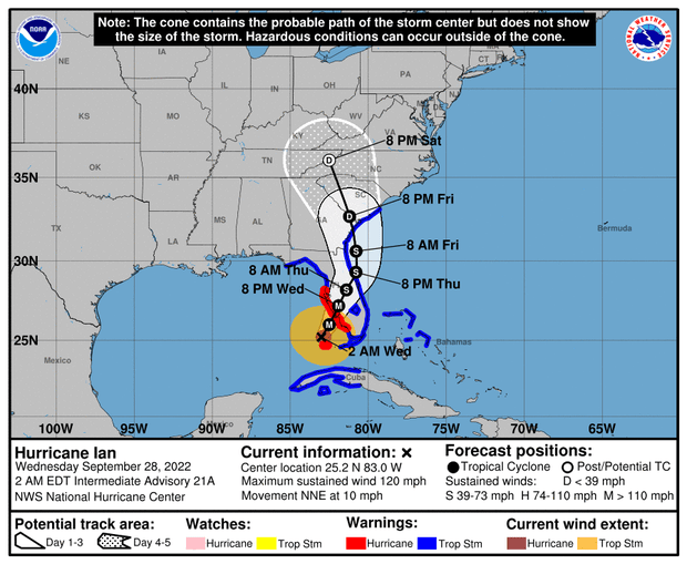
The Category 3 hurricane was still packing sustained winds of 120 mph as it churned north-northeast toward Florida's southern west coast, with the eye located about 90 miles southwest of the city of Naples at 3 a.m.
"Rapid intensification" seen with Ian is a rising trend
As Hurricane Ian roared towards Florida, it experienced a phenomenon known as rapid intensification — getting very strong, very fast. Scientists say the process of hurricanes rapidly intensifying is becoming more frequent, and is connected to the impact of human-caused climate change.
Rapid intensification is defined by meteorologists as increase in the maximum sustained winds of a tropical cyclone of at least 30 knots (about 35 mph) in a 24 hour period, according to the U.S. National Hurricane Center.
Click here to learn more about rapid intensification, how it's been a factor with Hurricane Ian, and the role climate change plays in the increase of the phenomenon.
